MVP Development,
GIS Development,
GPS Data Integration
Project Overview
A non-emergency medical transportation (NEMT) company aimed to revolutionize its transportation management system. By partnering with GIS Art, they successfully overcame critical challenges, optimized routes, reduced costs, and significantly improved operational efficiency through a custom GIS solution.
Сhallenge
The NEMT company struggled with inefficiencies in its transportation management system.
Manual data entry errors in addresses led to failed trips and financial losses.
Reliance on drivers’ knowledge instead of real-time data caused suboptimal routing and low On-Time Performance (OTP).
Pricing inaccuracies due to a lack of automated mileage and toll calculations further impacted profitability.
Additionally, the absence of effective driver control mechanisms resulted in delays and fraud risks.
To address these challenges, the company sought a partner with expertise in GIS and routing solutions capable of developing and supporting a complex IT system.
Solution
Our Approach
Adopting Agile Methodology
We used the Agile methodology, breaking the project into stages and iterations for flexibility,timely delivery, and minimizing risks.
Delivering the MVP
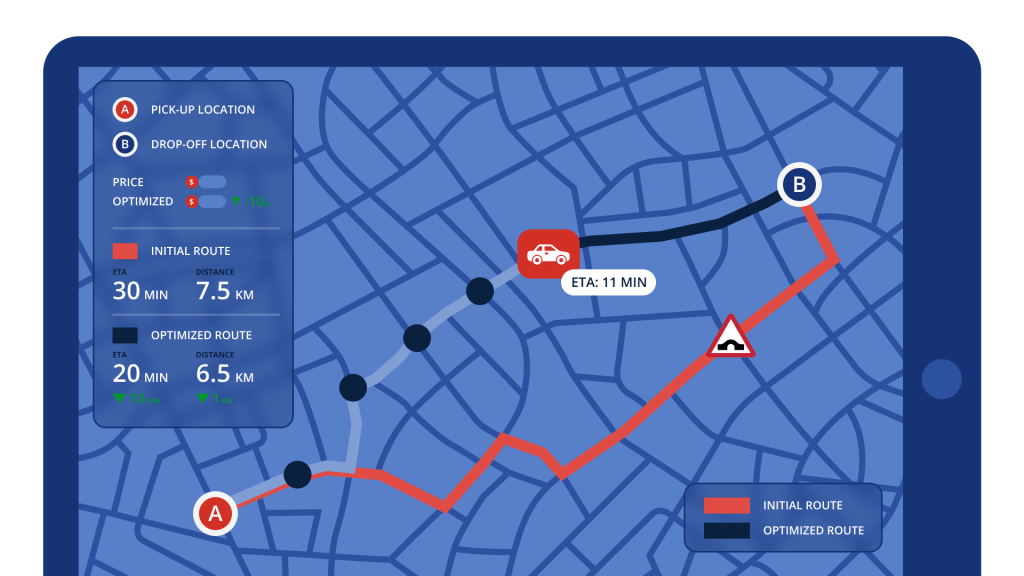
We began by implementing GIS features that offer maximum outcome with minimal implementation cost: automatic geocoding and validation of addresses and displaying them on a map, optimal route building and visualization, and automated pricing based on the optimal route mileage and tolls. This reduced failed trips and cost expenses, improved OTP, and set the foundation for future enhancements.
Ensuring Reliability Through Testing
The system underwent rigorous testing, including automatic UI and unit tests, to ensure reliability and faster updates.
Integrating GPS Data
A system for collecting, visualizing, and analyzing vehicle GPS data was added, enabling trip verification, fraud detection, and driver accountability. It also includes automatic determining vehicle ETA and the detection of delays in advance, which allows for reducing delays and failed/canceled trips, and improving customer satisfaction.
Optimizing Routing Costs
We implemented caching for geocoding and routing results to reduce costs for using the Google Maps API.
Main Features
Address Verification: Using auto-complete and geocoding to minimize errors in entered addresses, thus reducing failed trips and delays.
Route Optimization: Automatic building and displaying the cheapest routes to reduce transportation costs and travel times, and improve OTP.
GPS & ETA Tracking: Monitoring vehicle locations in real-time to predict ETAs and detect delays to minimize them through reroutes.
GPS Data Collecting & Analysis: Collecting, visualizing, and analyzing vehicle GPS data to verify trip completion and payment conditions, prevent fraudulent claims, and ensure driver accountability.
Trip Pricing Automation: Calculating trip prices accurately based on optimal/real route mileage and tolls for better profitability.
To ensure maintainability, scalability, and flexibility, we applied the MVC architectural pattern and the RESTful API style.
Collecting the GPS data was implemented as a separate microservice for better maintainability, scalability, and reliability. This approach allowed us to use optimal technologies for this functionality (PostgreSQL, .NET, C#).
INFRASTRUCTURE
Employment on AWS Cloud ensured scalability, reliability, and compliance with HIPAA standards.
Used Docker for streamlined deployment and consistent environments across development and production.
Business Outcomes
The NEMT business received a custom GIS solution developed by GIS Art that optimized routes, automated pricing, and enabled real-time GPS tracking. The project significantly enhanced efficiency and increased client revenue.
Operational Efficiency Significant reduction in failed/canceled trips and delays, and increased performance due to optimized routes, automated address verification, and real-time GPS and ETA tracking
Cost Savings Decreased cost expenses thanks to route optimization and automated pricing.
Revenue Increase Increased completed trips due to enhanced operational efficiency.
Contract Wins Enabled the company to secure new contracts with the optimized transportation platform.
Scalability
The platform’s robust architecture supports ongoing enhancements and scaling.
Customer Satisfaction Improved patient experience due to reliable and timely transportation services.
The NEMT business received a custom GIS solution that streamlined its operations and significantly improved its business efficiency and growth potential.
Client Review
Contact us
Start the Conversation Today
Looking to optimize your business with GIS solutions?
As the CTO of GIS Art, I can help boost operations and enhance customer experience through efficient GIS implementation. Unravel patterns and actionable insights derived from spatial data. With over 15 years of software development expertise in Healthcare, Real Estate, Transportation, Logistics, and beyond, we can unlock the potential of your business.