Home » Portfolio » GIS-Powered Property Assessment Tool
Project detAils
Case Study Summary
Industry
Real estate
Client
A digital consultancy company
Project duration
1 year
Location
Australia
Team
2 FTE
Services
Full-stack development, GIS development
Project overview
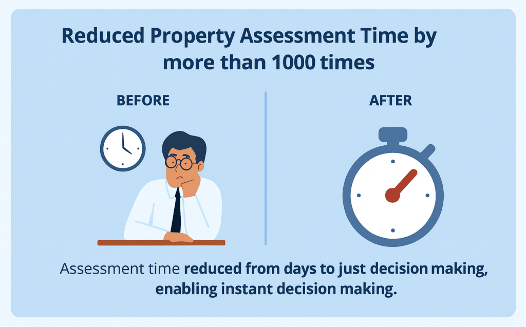
An Australian digital consultancy company needed a faster way to assess property development potential for a PropTech company. We built a GIS-powered tool that uses geospatial data analysis to deliver accurate reports in seconds, replacing slow manual processes and cutting assessment time by more than 1000 times.
Сhallenge
Assessing property development potential traditionally involved slow, manual processes that delayed decision-making. Determining whether a property could be subdivided or developed often required days of back-and-forth with town planners. This approach was time-consuming, prone to errors, and inefficient in handling large volumes of data.
Another challenge was integrating the needed geospatial data from multiple sources, and the large amount of data.
The challenge also included building a user-friendly interface accessible to users with varying levels of technical expertise.
At the same time, the system needed to scale to handle growing data demands.
The PropTech company sought a solution that could integrate multiple geospatial data sources, process complex calculations quickly, and generate detailed reports instantly.
SOLUTION
The client received an interactive web tool that enables instant property development assessments for any location in Australia by simply entering an address.
OUR Approach
Business Analysis
First, we conducted in-depth consultations with stakeholders to fully understand their requirements and align the solution with their business goals. This step ensured the tool addressed operational challenges while delivering a seamless user experience.
User Experience Design
We designed an intuitive interface tailored to users with varying tech skills. The layout prioritized clarity and ease of use, enabling effortless navigation and report generation.
Data Integration
We integrated geospatial data from multiple sources, building robust pipelines for real-time updates. This approach ensured the data was accurate, consistent, and ready for immediate analysis.
MVP Development
To kickstart the project, we developed a minimum viable product (MVP) with essential features. This included property search, map display, and basic reporting capabilities, providing a functional tool to test and refine core functionalities.
Complex Calculations
Our team developed algorithms for complex property-related calculations, such as frontage measurements and zoning assessments. These dynamic features allowed the tool to generate precise and actionable reports instantly.
Performance Optimization and Scalability
To enhance performance, we implemented caching mechanisms and optimized data queries. These improvements ensured fast and reliable data retrieval, delivering a seamless experience for users. <br>The tool was built with a scalable MVC architecture to accommodate future growth and advanced features.
Main Features
Data Integration
Automatic, customizable scraping of geospatial data from multiple open sources, with monitoring of the process.
Property Selection
Input an address with autocomplete, and the system automatically selects the property on the map. Alternatively, you can manually select a property on the map.
Frontage Detection
Identification and visualization of property frontages, considering them in the development potential assessment.
User Management
Sign-up, inviting multiple users to an account.
Data Visualization
Detailed map with multiple layers, including residential zones, biodiversity areas, bushfire zones, transportation networks, and more
Property Assessment Report
Generation of a PDF report with the property development potential assessment results, including insights into zoning regulations, highlighting risks, and maps.
Development Potential Assessment
Analysis of combining and subdivision variants, building options, zoning regulations, and restrictions.
Subscription and Payment
Payment for the generated reports according to the chosen subscription and promo codes.
Tech Stack and Architecture
Tech Stack
GIS: Leaflet, Google Maps
Frontend: JavaScript, jQuery, HTML, CSS
Backend: PHP, Codeigniter, Stripe
Database: PostgreSQL, PostGIS
Infrastructure: AWS Cloud
Software Architecture
The system was designed with the MVC architectural pattern to ensure scalability and maintainability, allow seamless integration of new features, and support long-term adaptability as user demands grow.
Infrastructure
The solution leverages a cloud-based infrastructure to provide high availability, security, and scalability. This setup supports smooth performance and reliability, even as the system scales to accommodate increased data and user needs.
Business Outcomes
The PropTech company achieved measurable results through our partnership, transforming how property assessments are conducted:
Reduced Property Assessment Time by more than 1000 Times The property assessment process was reduced from days to just 5–30 seconds, enabling users to make informed decisions instantly.
Decreased Data Management Expenses by more than 10 Times GIS Art automated the geospatial data update processes, cutting the time required by more than 10 times.
Reduced Legal Risks with Accurate Reports The client now provides detailed, precise reports that help users avoid fines and comply with zoning laws and environmental regulations.
These outcomes highlight the tangible benefits the client gained by partnering with GIS Art. They improved efficiency, reduced risks, and positioned themselves for sustained growth in the PropTech market.
Client Review
Contact us
Start the Conversation Today
Looking to optimize your business with GIS solutions?
As the CTO of GIS Art, I can help boost operations and enhance customer experience through efficient GIS implementation. Unravel patterns and actionable insights derived from spatial data. With over 15 years of software development expertise in Healthcare, Real Estate, Transportation, Logistics, and beyond, we can unlock the potential of your business.